
Surely you’ve seen the Instagrammable photos with lush green mountains and ancient stone buildings, but where exactly is Machu Picchu?
The citadel of Machu Picchu is located about 45 miles northwest of Cusco . At an elevation of 7,972 feet, many people are surprised to learn that it is actually lower than the elevation of Cusco (11,150 feet). It is part of the Urubamba province, a highly inaccessible post of the upper rainforest region of Peru. The nearest town, which acts as a base camp to Machu Picchu, is Aguas Callientes. This beautiful village of about 5,000 people is only accessible by train. Here you will find food and lodging before visiting the Incan world wonder.
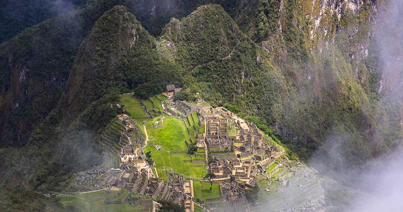
The site is actually located on two mountains – Huayna Picchu and Machu Picchu – that belong to the larger Vilcabamba batholith, a chain of high mountains that form part of the South Central Andes. These mountains are crossed by the Urubamba river creating a valley that carries the same name, but was formerly known as the Picchu brook. The ruins are located somewhere in between the bottom of the valley and the peak of the mountains, at approximately 1,500 feet above the river level. The total of the area covered by the ruins are around one million square feet, which includes almost two hundred main buildings within.
The site itself is part of a larger sanctuary that carries the same name, and it is one of the several places protected by the National System of Natural Areas Protected by the State (SINANPE, by its initials in Spanish). The Sanctuary of Machu Picchu has a total extent of nearly 33,000 hectares and is a natural reserve for multiple species of flora and fauna – including Peru’s national bird, the Gallito de las Rocas – as well as numerous Incan sites.
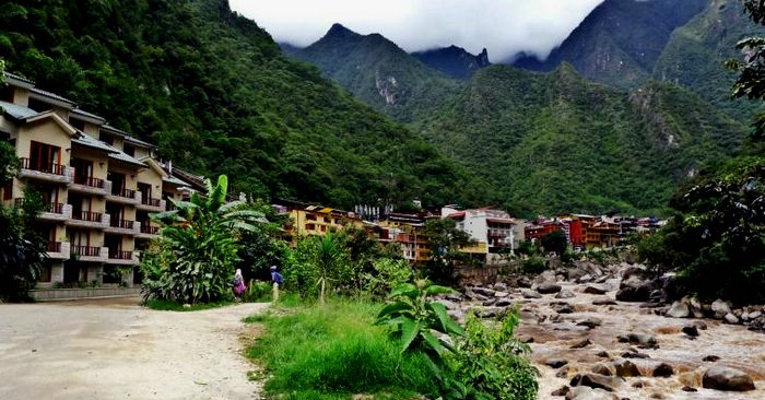 Get there by train or on foot, Aguas Calientes will definitely be on your
Machu Picchu travel itinerary. Photo by ohocheese/Flickr
Given the remoteness of the site, the access routes are somewhat limited. although it favors the protection of the site from erosion due to excessive transit. You will basically face two options, both of which will take you to the town of Aguas Calientes . You can either: 1) walk to the ruins, or 2) take the train.
The trekking route, better known as the Inca Trail , covers a total of 20 miles along an ancient Inca road. The train leaves from Cusco city, and takes approximately three hours across an area known as the Sacred Valley to get to Aguas Calientes. In both cases, you will need to take a twenty minutes bus ride along the Hiram Bingham highway to get to the ruins.
Machu Picchu Tours:
The location of the ruins are intimately linked with the original purpose of the construction. It was built by Pachacútec around 1450 A.D. as an urban center for religious, political, and agricultural purposes. In that sense, Machu Picchu was far from isolated, and belonged to a larger network of sites and outposts that linked production from different altitudinal layers and maximized the economic prevalence of Pachacútec and his family. Its position in between Cusco city, the inner core of the Inca state, and the lower rainforest valley turned the ancient citadel into a pivotal settlement for Incan interests in an age of imperial expansion. As such, the place had to be safeguarded from both rivaling populations and other competing Incan families. Machu Picchu was also an impassable garrison with very deep precipices that serve as a natural barrier against possible attacks. However, after the death of Pachacútec and the rise of new Incas and their families or panacas, the city lost its predominance due to the mounting importance of new possessions and settlements.
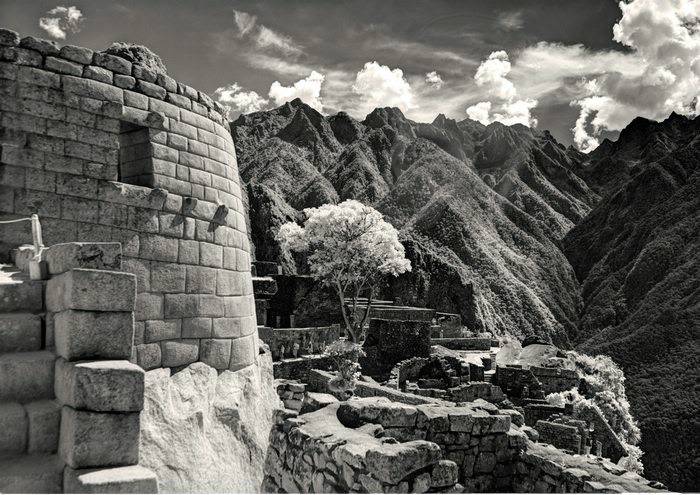 Machu Picchu remained abandoned for many years, earning the nickname “The
Lost City.” Photo by William Derby/Flickr
By the times of the Spanish conquest, Machu Picchu’s remaining nobles abandoned the city seeking for shelter under the command of Manco Inca. This is probably the origin of the “lost city” narrative. On the other hand, the site stayed inhabited by settlers and became part of the Spanish domain under the control of Hernando Pizarro, encomendero of Ollantaytambo . There are a few accounts about early colonial life in Machu Picchu, such as Spanish soldier Baltasar de Ocampo’s narration of a “majestic city on top of the hill” in the last years of Inca resistance (1570), as well as Titu Cusi Yupanqui’s call to the Augustine frays to evangelize the “Piocho” region.
Contemporary visitors will observe that two main sections compose the site: the urban and the agricultural. Likewise, the urban area is split into two parts: the lower town and the upper town. Most worshipping structures are located in the upper western section while the lower eastern area is almost exclusively devoted to housing facilities. There is one central square surrounded by multiple terraces, upon which all of the buildings were erected. Other terraces are used for agriculture, though these differ in size and present hydraulic structures that allow agriculture to flourish.
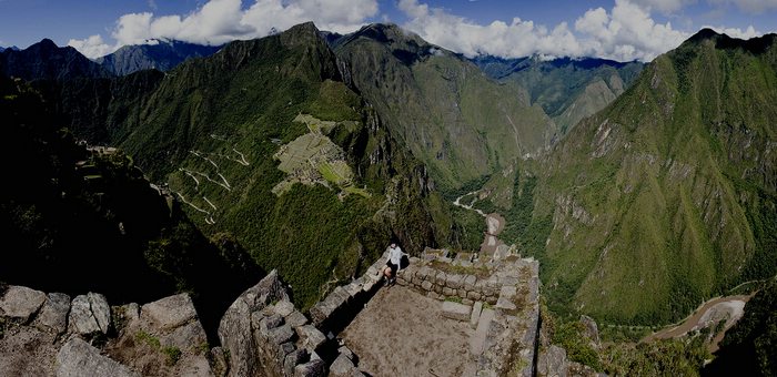 Look down at Machu Picchu from atop Huayna Picchu. Photo by Fernando
Stankuns/Flickr
All in all, Machu Picchu is a magnificent triumph of Inca architecture and urbanism. While many mysteries surround the site, every day we learn more about its history, its significance, and its contemporary relevance for both tourism and the history of Peru at large.
Check out our complete online Machu Picchu Travel Guide . Learn about how to get to Machu Picchu . Watch a National Geographic video about these Inca ruins .
Let our team of travel advisors get you to Machu Picchu worry-free. Contact us now, and we’ll help you plan your dream vacation to Peru!

Email: [email protected]
Sign up to receive our newsletter for great articles, stunning photos, and special deals.